Haw Creek in Columbus is an unregulated drain responsible for the runoff from an extensive area of regulated drains.
1) Haw Creek functions as a regulated drain except that it isn't fully regulated. The lower end of Haw Creek that traverses the City of Columbus is approx. six (6) miles long and is not a legally established Regulated County Drain.
2) The Haw Creek drainage area is 37,300 acres or 58.3 square miles and includes portions of southern Shelby County.
3) High water marks from the June 7, 2008 flood that caused an estimated $500 million dollars in damages were documented by the County Surveyors office and indicated there was approx. thirty (30) feet of fall through the City.
4) Water came within 3 feet of the 2008 flood event on December 23, 2013 and has been at flood stage five other times since 2011. Water levels rise frequently and are volatile on Haw Creek.
5) The waterway openings under the seventeen (17) bridges on the lower end of Haw Creek were roughly measured including the three (3) on the City Golf Course. The 18th Street and the Louisville & Indiana Railroad bridges were found to be considerably undersized. The head loss caused by the railroad bridge was 8 feet as documented at the time of the flood which is very excessive.
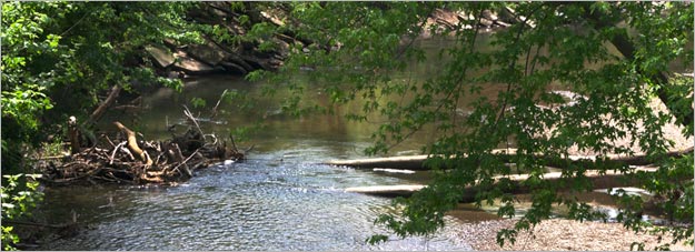
6) An inventory of the channel itself was done with the following findings:
a) Fallen trees and debris need to be removed from twenty-nine (29) locations that are major obstructions to flow.
b) Live trees are leaning out in seventeen (17) locations also blocking flow.
c) Twelve (12) areas of the adjacent flood plain need to be cleared to allow for unobstructed out-of-bank flow.
d) Two (2) concrete dams were noted in the channel, one (1) with a 8 ft. drop south of Rocky Ford Road and one (1) with a 6 ft. drop upstream from 25th Street.
e) A major accumulation of sediments has occurred between the State Street and the 7th Street bridges.
![]()
![]()